| Home > Articles > Fieldnotes: Armstrong Tunnels | |||
|
|
Field Notes: Armstrong Tunnels and South Tenth St In response to an e-mail inquiry: > > Where can I find out about the Armstrong Tunnel? < < The Armstrong Tunnel was built 1926-27. It features twin bores of horseshoe cross-section with a bend part of the way through. It also has a pedestrian walkway on the western side. Mark Rauterkus reports that the air draft flows toward the river -- allowing bicyclists to travel through the tunnel in that direction with little or no effort. It runs from Second Av at the South Tenth St Bridge, under the Bluff (Boyd's Hill) where Duquesne University is located, to Forbes Av between Boyd St and Washington Pl. One legend states that the bend in the tunnel was a mistake...and that the responsible party committed suicide in shame. Mr. Covell, of course, lived on to build again. Although they didn't have GPS or laser guided measuring systems in those days, I doubt they would have been off by that much without being aware of it. I suspect it had more to do with mines or other geological factors, property rights (including Duquesne University), alignments with existing or proposed roads (like the 10th St Bridge).
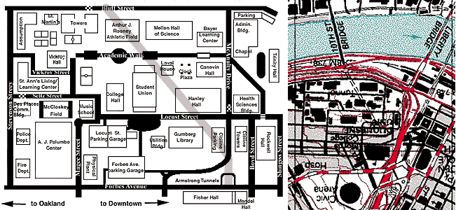
Comparing two maps gives more clues. One is the USGS topo map and the other is a Duquesne University Campus map with the buildings labelled. If you compare the two (unfortunately they are oriented exactly opposite each other north-south), you can see the tunnel carefully threads its way between the university buildings...under parking lots and the athletic field...just barely skirting the corners of a couple buildings. Many of the buildings were constructed after the tunnel, but certainly the placement of each is related. There was also a Tunnel St (now Chatham St) which ran parallel to the northern section of Washington Pl and the eastern section of Sixth Av (therefore at an approximate 45 degree angle in relation to Forbes Av). The southern end of Tunnel St nearly aligns with the northern portals of the Armstrong Tunnels, but does not connect directly. This is all coincidence: Tunnel St was long ago named for the sealed-off, but still existing, Pennsylvania Canal tunnel which was cut through Grant's Hill about 1829. Where Tunnels St would have possibly met the Armstrong Tunnels, the block between Fifth Av and Forbes Av is filled by the former Fisher Scientific headquarters (now labelled as Fisher Hall on the Campus Map). The northern tunnel portal appears on the Campus Map. The southern portal would be at the top, just to the right of where the checkerboard pattern is shown on Bluff St. A bridge has crossed the Monongahela River at South Tenth Street since the early 1800s when a wooden covered bridge was built. A metal (probably iron) truss bridge replaced the wooden structure c.1875. One of Pittsburgh's inclines was located near the northern end of the bridge. The Fort Pitt incline began operation in 1882. A city-owned concrete stairway traces the approximate path of the incline and some remnants of stone foundations may be seen there. When Pittsburgh annexed the town of Birmingham (South Side), there were calls for better access to the south shore of the Mon. Most of the traffic had relied on crossings at Smithfield St. And further upstream, the Brady St Bridge was built at South 22nd St in 1896. Between these two crossings, the proposal to open a passage under Boyd's Hill was seen as a way to relieve traffic in the upper Triangle and increase access to the South Side. Although the Liberty Tunnels had been completed previously, in 1922, with concrete portals, the Armstrong Tunnels were given Italian Renaissance stone walls and cut-stone portals -- the end of an era and the beginning of modern construction materials. With the increase of traffic brought by the Armstrong Tunnels and the condition of the c.1875 truss bridge at South Tenth St, Pittsburgh's only conventional suspension river bridge was built in 1931. At 750 ft, it is the longest span on the Monongahela River. The tunnel portals were designed by City architect Stanley L. Roush who was also noted for the Smithfield St Bridge portals, the City-County Building, the Corliss Tunnel, the lowering of the Courthouse entrance and many other City projects. Vernon R. Covell of the Allegheny County Public Works Department was the chief engineer. His name is found on many bridges of that time. The tunnels were named in honor of Joseph G. Armstrong, who had served as Director of Public Works at a most active time in Allegheny County. Most of the bridges over the three rivers were replaced between 1910 and 1940, which included Mr. Armstrong's terms as Mayor of Pittsburgh and Allegheny County Commissioner. Between 1956 and 1958, the Penn Lincoln Parkway was built over the now-removed Baltimore and Ohio passenger terminal tracks. The elevated section of the westbound lanes and the Second Av ramp were constructed directly in front of the southern portal of the Armstrong Tunnels. The stone portals are now mostly obscured by the ramps, but the top of the cornice with the name of the tunnels may be seen from the highway. Duquesne University campus map from www.duq.edu/campusmap/map.gif
Submit info or inquiry - share some facts or ask a question.
Page created:
Page created:
12-Apr-2000
|
||
| copyright: © Bruce S. Cridlebaugh 1999-2008 All Rights Reserved | |||