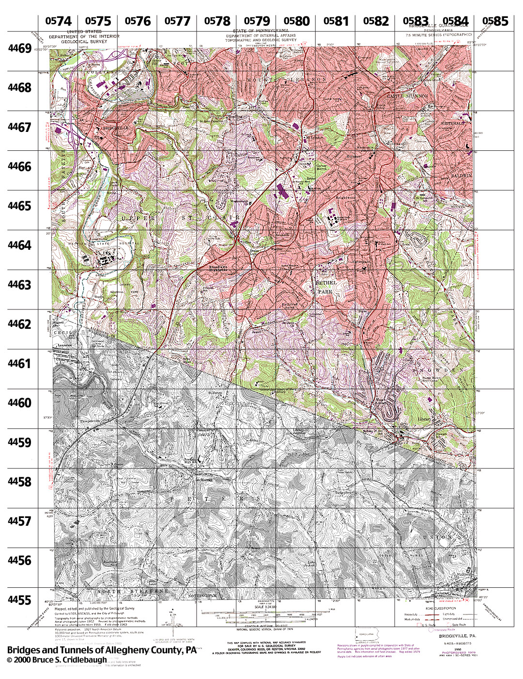
Structures Listed by Location
BRIDGEVILLE, PA - USGS 7.5" Topo Quad - UTM grid location in BOLD
view map - initial listings completed 15-Feb-2000
* indicates unconfirmed crossing
80° 07' 30" W --- 80° 00' 00" W;
40° 22' 30" N --- 40° 15' 00" N
Also try the Tours.
0574 4469
grid location also on Canonsburg and Pittsburgh West topo quads
- Boyds Run Rd over tributary of Chartiers Creek (Collier)
- Thoms Run Rd [Orange Belt] over tributary of Chartiers Creek (Collier)
- Presto-Sygan Rd over Thoms Run (Collier - South Fayette)
0574 4468
grid location also on Canonsburg topo quad
- Road to factory over Millers Run, off Presto-Sygan Rd, east of Bethany Cemetery (South Fayette)
0574 4467
grid location also on Canonsburg topo quad
- NW RR [Wabash] over Chartiers Creek (Bridgeville - South Fayette)
- I-79 over NW RR, Conrail and Chartiers Creek (Bridgeville - South Fayette)
- Conrail over Chartiers Creek (Bridgeville - South Fayette)
- I-79, Interchange 11, Bridgeville [PA50] (South Fayette)
0574 4466
grid location also on Canonsburg topo quad
- I-79 over Coal Run (South Fayette)
0574 4465
grid location also on Canonsburg topo quad
- none listed
0574 4464
grid location also on Canonsburg topo quad
- none listed
0574 4463
grid location also on Canonsburg topo quad
- Boyce Rd and Mayview Rd over tributary of Chartiers Creek (South Fayette)
0574 4462
grid location also on Canonsburg topo quad
- Mayview Rd over tributary of Chartiers Creek (South Fayette)
0575 4469
grid location also on Pittsburgh West topo quad
- Prestley Rd [Orange Belt] over Chartiers Creek (South Fayette)
- Prestley Rd [Orange Belt] over I-79 (Collier)
- I-79 over Chartiers Creek, south of Interchange 12 (Collier)
0575 4468
- Washington Av [PA50] over Chartiers Creek (Bridgeville - Collier)
- NW RR [Wabash] over Chartiers Creek, south of Mayer St (Bridgeville - Collier)
- NW RR over Washington Rd [PA50 - Orange Belt] (Bridgeville)
0575 4467
- Murray St at NW RR [Wabash] (Bridgeville)
- Washington Av [PA50] over Conrail, south of Station St (Bridgeville)
- Conrail over McLaughlin Run (Bridgeville)
- Bluff St [Bower Hill Rd?, McLaughlin Rd?] [Orange Belt] at Conrail (Bridgeville)
- Bluff St [Bower Hill Rd?, McLaughlin Rd?] [Orange Belt] over McLaughlin Run, west of Union Av (Bridgeville)
- Station St over Conrail Washington Branch (Bridgeville)
view page
- Baldwin St over McLaughlin Run (Bridgeville)
view page
- McLaughlin Rd [Orange Belt] over McLaughlin Run, at Maple Av (Bridgeville)
- Washington Av [PA50] over Chartiers Creek, south of Chartiers St (Bridgeville - South Fayette)
- Chartiers St over Conrail Washington Branch, at Dewey Av (Bridgeville)
- Conrail Washington Branch over Chartiers Creek, near Dewey Av (Bridgeville - South Fayette)
0575 4466
- Conrail Washington Branch over Coal Run, east of Melrose Cemetery (South Fayette)
- Washington Pike [Morganza Rd] over Coal Run, south of Melrose Cemetery (South Fayette)
- Conrail Washington Branch over tributary of Chartiers Creek, west of Freedom Dr (South Fayette)
0575 4465
- Pedestrian bridge over Chartiers Creek (South Fayette - Upper St. Clair)
0575 4464
- Mayview Rd over Chartiers Creek (South Fayette - Upper St. Clair)
- Mayview Rd at Conrail Washington Branch (South Fayette - Upper St. Clair)
0575 4463
- Mayview Rd over tributary of Chartiers Creek (South Fayette)
- Conrail Washington Branch over Chartiers Creek, south of Mayview Hospital (South Fayette - Upper St. Clair)
- Boyce Rd over Chartiers Creek (Upper St. Clair)
- Conrail Washington Branch at Boyce Rd (Upper St. Clair)
0575 4462
- none listed
0576 4469
grid location also on Pittsburgh West topo quad
- I-79, Interchange 12, Kirwin Heights (Collier)
- Vanadium Rd at Conrail
- Vanadium Rd at NW RR [Wabash] (Collier)
- NW RR [Wabash] over Montgomery Av, Conrail and Chartiers Creek (Collier - Scott)
- Conrail over Chartiers Creek, north of Montgomery Av (Collier - Scott)
- Montgomery Av over Chartiers Creek (Collier-Scott)
0576 4468
- Meyer St - Beram Av over NW RR [Wabash] (Collier)
- Conrail over Chartiers Creek, north of Union St (Bridgeville - Collier)
- Road to factory from Bower Hill Rd over Chartiers Creek (Bridgeville - Collier)
- Bower Hill Rd over Painters Run (Upper St. Clair)
0576 4467
- McLaughlin Run Rd [Orange Belt] over McLaughlin Run (Bridgeville)
0576 4466
- Mayview Rd over tributary of Chartiers Creek, Ravine Park (Upper St. Clair)
0576 4465
- none listed
0576 4464
- Morton Rd over tributary of Chartiers Creek (Upper St. Clair)
0576 4463
- none listed
0576 4462
- Circle Dr over tributary of Brush Run, at Turnberry Dr (Upper St. Clair)
- Circle Dr over tributary of Brush Run, at Pinetree Dr (Upper St. Clair)
0576 4461
- Washington Rd [US19] over tributary of Brush Run, at Circle Dr (Upper St. Clair)
0577 4469
grid location also on Pittsburgh West topo quad
- none listed
0577 4468
view page
- Pittsburgh, Chartiers and Youghiogheny Railroad, PCY RR Essen Tunnel [abandoned] (Scott - Upper St. Clair)
- Bower Hill Rd over Painters Run (Scott - Upper St. Clair)
- Painters Run Rd over Painters Run (Scott - Upper St. Clair)
0577 4467
- none listed
0577 4466
- McLaughlin Run Rd [Orange Belt] over tributary of McLaughlin Run (Upper St. Clair)
- McLaughlin Run Rd over tributary of McLaughlin Run, north of McMillan Rd (Upper St. Clair)
- Lesnett Rd over McLaughlin Run (Upper St. Clair)
0577 4465
- Morrow Rd over tributary of Chartiers Creek (Upper St. Clair)
0577 4464
- none listed
0577 4463
- Partridge Run Rd over tributary of Brush Run (Upper St. Clair)
- Chapelwood Dr over tributary of Brush Run (Upper St. Clair)
- Washington Rd [US19] over tributary of Brush Run (Upper St. Clair)
0577 4462
- Boyce Rd over tributary of Brush Run (Upper St. Clair)
- Old Washington Rd over tributary of Brush Run (Upper St. Clair)
- Hays Rd over tributary of Brush Run (Upper St. Clair)
0577 4461
- Hays Rd over tributary of Brush Run (Upper St. Clair)
0578 4469
grid location also on Pittsburgh West topo quad
- none listed
0578 4468
- Kelso Rd over tributary of Painters Run, at Robb Hollow Rd (Mt Lebanon)
- Painters Run Rd over tributary of Painters Run (Mt Lebanon)
0578 4467
- Painters Run Rd over Painters Run, north of McMillan Rd (Upper St. Clair)
- Fort Couch Rd over tributary of Painters Run, at McMillan Rd (Upper St. Clair)
0578 4466
- McMillan Rd over tributary of McLaughlin Run, multiple crossings between McLaughlin Run Rd and Ohr Rd (Upper St. Clair)
0578 4465
- Morrow Rd over McLaughlin Run (Upper St. Clair)
- Swanson Ln over McLaughlin Run (Upper St. Clair)
- McLaughlin Run Rd [Orange Belt] over tributary of McLaughlin Run, at Truxton Dr (Upper St. Clair)
0578 4464
- McLaughlin Run Rd [Orange Belt] over tributary of McLaughlin Run, west of Washington Rd [US19] (Upper St. Clair)
- Washington Rd [US19] over McLaughlin Run Rd and McMurray Rd {Orange Belt} (Upper St. Clair)
- Country Club Rd over Washington Rd [US19] (Upper St. Clair)
0578 4463
- none listed
0578 4462
- none listed
0578 4461
- none listed
0579 4469
grid location also on Pittsburgh West topo quad
- Linendale Dr over tributary of Painters Run, at Lake Wy (Mt Lebanon)
0579 4468
- Lindendale Dr over tributary of Painters Run, at Cedar Blvd (Mt Lebanon)
- Gilkeson Rd over Painters Run, second crossing west of Cedar Blvd (Mt Lebanon)
- Gilkeson Rd over Painters Run, first crossing west of Cedar Blvd (Mt Lebanon)
- Bridge St over Painters Run (Mt Lebanon - Upper St. Clair)
0579 4467
- Gilkeson Rd over Painters Run, east of Cedar Blvd (Mt Lebanon)
- Old Gilkeson Rd over Painters Run, east of Cedar Blvd (Mt Lebanon)
- Upper Rd over tributary of Painters Run, near Locust Ln (Upper St. Clair)
0579 4466
- none listed
0579 4465
- Ohr Rd over tributary of McLaughlin Run, near Washington Rd (Upper St. Clair)
0579 4464
- Walther Rd over Graesers Run (Bethel Park - Upper St. Clair)
- Old Drake trolley line over McLaughlin Run, at McMurray Rd (Upper St. Clair)
- Bethel Church Rd over McLaughlin Run (Upper St. Clair)
- McMurray Rd [Orange Belt] over tributary of McLaughlin Run (Upper St. Clair)
0579 4463
- Old Drake trolley line over Wiltshire Dr (Upper St. Clair)
- Wiltshire Dr over tributary of McLaughlin Run (Upper St. Clair)
0579 4462
- Montour RR [abandoned] at Clifton Rd [Orange Belt] (Bethel Park)
0579 4461
- [Rocky Ridge: highest point in Allegheny County]
0579 4460
- none listed
0580 4469
grid location also on Pittsburgh West topo quad
- none listed
0580 4468
- none listed
0580 4467
- Iroquois Dr over Painters Run (Mt Lebanon)
- Washington Rd [US19 - Yellow Belt] over Painters Run (Mt Lebanon)
0580 4466
- none listed
0580 4465
- Port Authority "T" over Fort Couch Rd (Bethel Park)
- Fort Couch Rd over Graesers Run (Bethel Park)
0580 4464
- Brookside Blvd over Graesers Run (Bethel Park)
- Bethel Church Rd over tributary of Graesers Run, east of Woodford Rd (Bethel Park)
- Logan Rd [Clifton Rd?] over tributary of Graesers Run (Bethel Park)
- Greenwald Rd over tributary of Graesers Run (Bethel Park)
0580 4463
- Montour RR [abandoned] over Logan Rd, at Irishtown Rd (Bethel Park)
0580 4462
- none listed
0580 4461
- Thunderwood Rd over Piney Fork (Bethel Park)
- Rocky Ridge Rd over Piney Fork (Bethel Park)
- Havengate Rd over Piney Fork (Bethel Park)
- Mountain Av over Piney Fork (Bethel Park)
- Clifton Rd [Orange Belt] over tributary of Piney Fork (Bethel Park)
0580 4460
- none listed
0581 4469
grid location also on Pittsburgh West topo quad
- none listed
0581 4468
- none listed
0581 4467
- Terrace Dr over Painters Run (Mt Lebanon)
0581 4466
- Highland Rd over Port Authory "T" (Bethel Park)
0581 4465
- Broad St over tributary of McLaughlin Run (Bethel Park)
0581 4464
- Church Rd over tributary of McLaughlin Run (Bethel Park)
- Montour RR [abandoned] at South Park Rd (Bethel Park)
0581 4463
- Logan Rd over tributary of Piney Fork (Bethel Park)
0581 4462
- Delaware Av over tributary of Piney Fork (Bethel Park)
- Laurel Av over tributary of Piney Fork (Bethel Park)
- Keystone Dr over tributary of Piney Fork (Bethel Park)
- Glendale Dr over tributary of Piney Fork (Bethel Park)
- Clark Av over tributary of Piney Fork (Bethel Park)
0581 4461
- Irishtown Rd over Piney Fork (Bethel Park)
- Clifton Rd [Orange Belt] over tributary of Piney Fork, at Kings School Rd (Bethel Park)
- Clifton Rd [Orange Belt] over tributary of Piney Fork, west of Airedale Dr (Bethel Park)
- Castle Dr over tributary of Piney Fork (Bethel Park)
0582 4469
grid location also on Pittsburgh West topo quad
- none listed
0582 4468
- Willow Av over tributary of Saw Mill Run, north of Bockstage Av (Castle Shannon)
- Port Authority "T" over tributary of Saw Mill Run, north of Bockstage Av (Castle Shannon)
- Road off Willow Av over tributary of Saw Mill Run, north of Bockstage Av (Castle Shannon)
- NW RR over Castle Shannon Blvd, Library Rd [PA88] and Port Authority "T" (Castle Shannon)
- Castle Shannon Blvd over Saw Mill Run (Castle Shannon)
- Rockwood Av over tributary of Saw Mill Run (Castle Shannon)
- NW RR over McCully Rd (Castle Shannon)
0582 4467
- Smith Rd over tributary of Saw Mill Run (Castle Shannon)
- NW RR over Smith Rd (Castle Shannon)
- Connor Rd [Yellow Belt] over tributary of Saw Mill Run (Bethel Park)
- NW RR over Valley Rd (Bethel Park)
- Port Authority "T" over Milford Dr (Bethel Park)
0582 4466
- Old Drake trolley line over tributary of Saw Mill Run, east of Caswell Dr (Bethel Park)
- Milford Dr over tributary of Saw Mill Run, east of Caswell Dr (Bethel Park)
- Horning Rd [old alignment] over Port Authority "T" (Bethel Park)
- Bethel Church Rd over Port Authority "T" (Bethel Park)
- Broughton Rd [Yellow Belt] over Montour RR [abandoned] (Bethel Park)
0582 4465
- Montour RR [abandoned] over Library Rd [PA88] (Bethel Park)
- Montour RR [abandoned] over Brightwood Rd (Bethel Park)
- Montour RR [abandoned] over Bridghtwood Rd and Library Av (Bethel Park)
0582 4464
- none listed
0582 4463
- none listed
0582 4462
- Kings School Rd over tributary of Piney Fork, near Library Rd (Bethel Park)
0582 4461
- Port Authority "T" over tributary of Piney Fork, at Beagle Dr (Bethel Park)
- Beagle Dr over tributary of Piney Fork (Bethel Park)
- Library Rd [PA88] over tributary of Piney Fork, at Phillippi Av (Bethel Park)
- Long Av over tributary of Piney Fork (Bethel Park)
0582 4460
- Port Authority "T" over tributary of Piney Fork, north of Clifton Rd (Bethel Park)
view page
- Library Rd [PA88] over tributary of Piney Fork, north of Clifton Rd (Bethel Park)
view page
- Library Rd [PA88] over tributary of Piney Fork, south of Clifton Rd (Bethel Park)
- Library Rd [PA88] over tributary of Piney Fork, south of Church Hill Rd (South Park)
view page
- Library Viaduct - Montour Trail [former Montour RR] over Library Rd [PA88], Port Authority "T", and Piney Fork (South Park)
0582 4459
- none listed
0583 4469
grid location also on Pittsburgh West topo quad
- Sleepy Hollow Rd over tributary of Saw Mill Run (Castle Shannon)
0583 4468
- NW RR over Sleepy Hollow Rd (Castle Shannon)
- Sleepy Hollow Rd over tributary of Saw Mill Run (Castle Shannon)
0583 4467
- NW RR over Ridgeway Dr (Bethel Park)
0583 4466
- Baptist Rd over NW RR (Bethel Park)
- Montour RR [abandoned] over Baptist Rd (Bethel Park)
- Montour RR [abandoned] over NW RR (Bethel Park)
- Montour RR [abandoned] over Horning Rd (Bethel Park)
0583 4465
- Horning Rd over Lick Run (Bethel Park)
- NW RR over Horning Rd (Bethel Park)
0583 4464
- Road in South Park over Catfish Run, off Corrigan Dr, north of circle (Bethel Park)
0583 4463
- none listed
0583 4462
- Kings School Rd over Sleepy Hollow Run (Bethel Park)
0583 4461
- Stotz Rd over Sleepy Hollow Run (South Park)
- Sleepy Hollow Rd over Sleepy Hollow Run (South Park)
0583 4460
- Montour RR [abandoned] over Pleasant St (South Park)
0583 4459
- Pleasant St over tributary of Piney Fork, north of Port Authority "T" (South Park)
- Pleasant St over Piney Fork, at Church St (South Park)
- Wresscom St over tributary of Piney Fork (South Park)
- First Av over tributary of Piney Fork (South Park)
- Montour RR yard [abandoned] over tributary of Piney Fork (South Park)
- Port Authority "T" over tributary of Piney Fork (South Park)
- Port Authority "T" over Piney Fork, at Pleasant Rd (South Park)
- Brownsville Rd over tributary of Piney Fork (South Park)
- Mine bucket lift [incline?] over Brownsville Rd and Montour RR (South Park)
0584 4469
grid location also on Glassport and Pittsburgh West topo quads
- Sixth St over tributary of Saw Mill Run (Castle Shannon)
0584 4468
grid location also on Glassport topo quad
- none listed
0584 4467
grid location also on Glassport topo quad
- none listed
0584 4466
grid location also on Glassport topo quad
- NW RR over Norma Dr (Baldwin)
- NW RR over Gardenville Rd (Baldwin)
0584 4465
grid location also on Glassport topo quad
- Horning Rd over Lick Run, at Gardenville Rd (Bethel Park)
- NW RR at Willis Rd (Bethel Park)
0584 4464
grid location also on Glassport topo quad
- Road in South Park over tributary of Catfish Run (Bethel Park)
0584 4463
grid location also on Glassport topo quad
- Corrigan Dr over tributary of Catfish Run, at Stone Manse Dr (South Park)
- Stone Manse Dr over Catfish Run (South Park)
- Maple Spring Dr over Catfish Run (South Park)
0584 4462
grid location also on Glassport topo quad
- Corrigan Rd over Catfish Run, south of Sesqui Dr (South Park)
0584 4461
- none listed
0584 4460
- Wood St over Piney Fork (South Park)
- Sleepy Hollow Rd over Sleepy Hollow Run (South Park)
- Montour RR [abandoned] over Stewart Rd (South Park)
- Stewart Rd over Piney Fork (South Park)
- Montour RR [abandoned] over Brownsville Rd (South Park)
0584 4459
- Brownsville Rd over Sleepy Hollow Run (South Park)
0584 4458
- none listed
Submit info or inquiry - share some facts or ask a question.
Page created:
Last modified:
30-Mar-2009, 06-Dec-2008, 08-May-2003
