| Home > All By Location regional map > Glassport > Ravensburg Bridge over Peters Creek | ||||||||||||
|
|
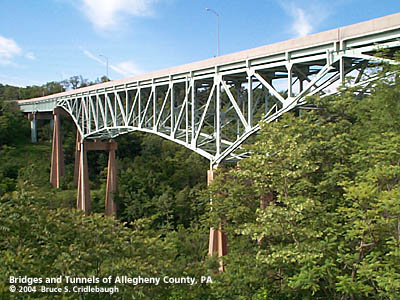
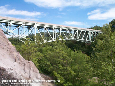 Twin spans flank 150 foot high slag hill: (left, north) Span above Peters Creek; (right, south) Span over WLE Railroad 
Elevation drawing looking downstream More detail photos OFFICIAL NAME: Ravensburg Bridge OTHER DESIGNATION: glas593-18/19 LOCATION: Clairton / Jefferson USGS 7.5" Topo Quad - UTM Coordinates: Glassport - Zone 17; 0593 4461 CARRIES: Ravensburg Blvd (20 ft roadway with 6 ft sidewalk on downstream side) BETWEEN: -- Wilson (First Ward, Clairton); south of PA885, N 8th St -- Clairton Municipal Building CROSSES: -- (north to south) Montour Trail (former PRR Peters Creek Branch); Peters Creek; Wheeling & Lake Erie RR (former West Side Belt RR) TYPE OF CONSTRUCTION / DESIGN: deck spandrel braced deck arch [cantilever] LENGTH OF MAIN SPAN: 840 ft over Peters Creek: (north to south) 125 ft girder; 155 ft girder; 125 ft truss counter; 250 ft spandrel braced deck arch [cantilever]; 125 ft truss counter; 60 ft girder 65 ft roadway atop slag pile; 500 ft over WLE RR: (north to south) 125 ft truss counter; 250 ft deck spandrel braced deck arch [cantilever]; 125 ft truss counter concrete bent towers TOTAL LENGTH (including longest elevated ramp): 1,405 ft HEIGHT OF DECK: 175 ft est (125 ft est clearance over Peters Creek) YEAR ERECTED / ENGINEER: 1963, Allegheny County? Opened August 25, 1966 City of Clairton, current owner Rehabilitated and re-opened December, 2001 ADDITIONAL INFO: Opened in 1966, the high-level Ravensburg Bridge connects the two halves of Clairton on either side of Peters Creek. Each end of the bridge lands in the City of Clairton, but the majority of the Peters Creek valley is within Jefferson borough. The bridge is two separate structures which meet atop a towering slag pile in the center of the deep, wide valley. The slag piles seem reminiscent of the Trümmerberge, the rubble mountains built in various locations in Berlin, Germany, after World War II to dispose of debris of destroyed city buildings. These mountains in Clairton, however, are by-products of the US Steel works along the Monongahela River -- visible from the bridge deck. The bridge is owned by the City of Clairton and is possibly the largest bridge in Pennsylvania owned by a local municpality. The design appears to be similar to those built by the County of Allegheny. $6.1 million was appropriated for rehabilitation in the PA state capital budget in 1986, but local matching funds were not available to complete the project. from PA state Rep. David Levdansky newsletter: City Engineer Frank Gross, former City Manager Jeff Braun and (Rep. Levdansky) convinced members of the State Transportation Commission to prioritize the project and get the ball rolling in 1991. In 1993 with the design plans ready to go, we ran into another roadblock. Clairton did not have the required $300,000 local match to get the construction started. The federal government was picking up 80 percent of the cost. The state would pick up 15 percent. That left the city to pick up the remaining 5 percent. But Clairton had been declared a financially distressed community by the state and was facing bankruptcy. The city and state worked together on a recovery plan that called for the city to turn its ownership of the Ravensburg Bridge over to the state or county. But the bridge was in such deplorable condition, neither one wanted it. (Rep. Levdansky worked) to get the support of House Appropriations Committee Chairman Dwight Evans from Philadelphia, former PennDOT Secretary Yerusalim, former Gov. Bob Casey and state Sen. Robert Jubelirer...and a law was passed making the state pay Clairton's $300,000 local match. Clairton was the only city in the state to benefit from this law. --- A metal builder's plaque is mounted on a concrete pedestal at the southern end of the bridge portal, across the street from the City of Clairton Municipal Building:
--- Benjamin Kuykendall [also Kirkendall, etc.] (1722-1789) is recognized as the earliest permanent European settler in the lower Peters Creek area. He is reported to have witnessed the 1754 march of Major Edward Hand away from Fort Pitt after surrendering the Point to the French. This was a time when the colonies of Virgina and Pennsylvania each laid claims to the area and prior to the legalization of settlements west of the Appalchian Mountains in 1763. Kuykendall and his family received the patent on the tract of land called "Ravensburg" from the Penns, yet he served as a justice in the courts of Yohogania County, Virginia. Tradition states "half-breed" Peter Chartiers, aka "Indian Peter" was the only native American to receive a land patent in the area. Both major streams which have watersheds partially on his lands, Peters Creek and Chartiers Creek, are named for the early settler. --- view page - Ravensburg Tunnel - Wheeling and Lake Erie RR [West Side Belt RR] visit site - History of Clairton (15122.com) FIELD CHECKED: 30-May-2004 INFO SOURCES: field check; PA Rep. David Levdansky; Montour Trail Council Submit info or inquiry - share some facts or ask a question. Introduction -- Nearby Structures Page created: Last modified: 02-Jun-2004 |
View Larger Map 
| ||||||||||
| copyright: © Bruce S. Cridlebaugh 1999-2008 All Rights Reserved | ||||||||||||