| Home > All By Location regional map > Pittsbugh East > Panhandle Bridge Wye -- southern approach | |||
|
|
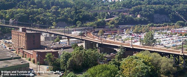
View west from Liberty Bridge: Panhandle Bridge out of view to right; western wye branch curves in center; eastern wye branch ascends to left More detail photos OFFICIAL NAME: OTHER DESIGNATION: Panhandle Bridge Wye pghe584-67 LOCATION: Pittsburgh USGS 7.5" Topo Quad - UTM Coordinates: Pittsburgh East - Zone 17; 0584 4475 CARRIES: Port Authority of Allegheny County (PAT) "T" light rail system -- two tracks on west wye branch to Mt. Washington Transit Tunnel originally built for Pennsylvania Railroad "Panhandle" Division (see additional info below) -- single track on east wye branch to Arlington Av originally built for Pennsylvania Railroad "Monongahela" Division (see additional info below) BETWEEN: -- Panhandle Bridge over Monongahela River -- west wye branch to Mt. Washington Transit Tunnel -- east wye branch to Arlington Av CROSSES: south approach, west wye branch: CSX RR (PLE); McKean St; East Carson St south approach, east wye branch: CSX RR (PLE); McKean St; South First St; East Carson St TYPE OF CONSTRUCTION / DESIGN: south approach, east wye branch: steel plate deck girder (nine spans) south approach, west wye branch: steel deck plate girder (nine spans) LENGTH OF MAIN SPAN: TOTAL LENGTH (including longest elevated ramp): HEIGHT OF DECK: YEAR ERECTED / ENGINEER: 1863, Pittsburgh and Steubenville Railroad Company rebuilt c1903, Pennsylvania Railroad rebuilt 1985, Port Authority of Allegheny County, Parsons Brinkerhoff ADDITIONAL INFO: This rail line was part of the route built by the Pittsburgh and Steubenville Railroad Company, a division of the Pittsburgh, Cincinnati, Chicago and St. Louis Railroad. The "Steubenville Extension" was later absorbed into the Pennsylvania Railroad. This line ran west to Steubenville, OH, crossing the "panhandle" of Virginia (West Virginia after the Civil War), thus the source of the nickname of the railroad and the bridge. The southern approach to the Panhandle Bridge splits into a wye south of the Monongahela River. This was the location of the Monon Tower ("MB"). Evidence of the original connections from the wye to the PRR (later Conrail, now Norfolk Southern) may be found in the old abutments, massive stone walls and repurposed piers. The western wye branch was the curving connection between the Monongahela River crossing -- first opened in 1863 -- and the railroad's route on a terrace at the base of Mount Washington. The bridge deck of 1863 structure was at the same elevation as downtown streets in the area and required grade crossings including Second St near the Try St Yard (site of Crosstown Blvd) and Fourth St Station (across Forbes Av [then Diamond St] from the old jail). Several of the piers on the western wye branch were widened and extended in height when the current Panhandle Bridge was built in 1903 and when it was raised up as part of a downtown grade separation project, 1912-1914. When the double-tracked western branch of the wye was part of the Panhandle Divison of the PRR, it led to a station at Smithfield St above the current location of the "T" light rail station near Station Square. As reconfigured, the "T" line descends to this street-level station at East Carson and Smithfield Streets, then curves into the Mt Washington Trolley Tunnel. Several of the original piers near the river were refurbished while those nearer to East Carson St were built in 1985. The single-track eastern (upstream) branch of the wye led to the Monongahela Division of the PRR. This line was first completed as the Pittsburgh, Virginia and Charleston Railway in 1873, but at first there was no connection to the Panhandle Bridge. The 1886 Hopkins map does not show the eastern wye branch; it appears complete on the 1903 edition. As reconfigured in 1985, the eastern wye branch connects to the Arlington line of the "T" light rail system on new steel deck girders and concrete hammerhead piers which rise higher than the PRR previously. Evidence of the location of the former connection to the Mon Division can be found in the stone retaining wall above East Carson St near South Second St. Since 1985, this route has been used as part of the "T" light rail system operated by the Port Authority of Allegheny County. The above ground light rail vehicles cross the Panhandle Bridge, pass under several buildings and enter the PRR tunnel under Forbes Av -- thereby entering the Pittsburgh subway. view page - Panhandle Bridge over Monongahela River FIELD CHECKED: 11-Sep-2002 INFO SOURCES: Kobus and Consoli, "The Pennsy in The Steel City" and "The Pennsylvania Railroad's Golden Triangle;" Lorant: "Pittsburgh: The Story of an American City;" Kidney: "Pittsburgh's Landmark Architecture"; 1886 and 1903 G. M. Hopkins maps Submit info or inquiry - share some facts or ask a question. Introduction -- Nearby Structures Page created: Last modified: 16-May-2003 |
View Larger Map 
| |
| copyright: © Bruce S. Cridlebaugh 1999-2008 All Rights Reserved | |||