| Home > All By Location regional map > Pittsbugh East > Lower P.J. McArdle Roadway | |||
|
|
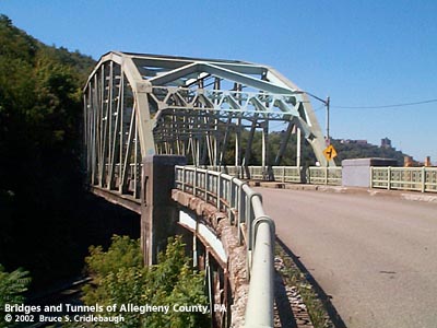
View west on Viaduct Number 1 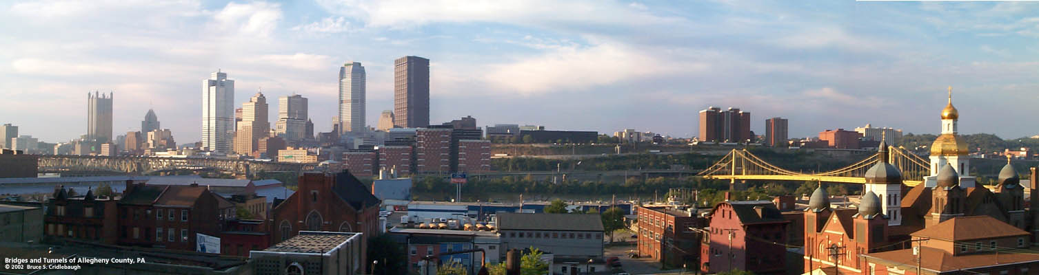 Panoramic view north from Viaduct Number 1
More detail photos OFFICIAL NAME: P. J. McArdle Roadway, Viaduct 1 (over Norfolk Southern Railroad) P. J. McArdle Roadway, Viaduct 2 (over ravine at Arlington Av) OTHER DESIGNATION: Lower McArdle Roadway Mt. Washington Roadway pghe585-45 LOCATION: Pittsburgh USGS 7.5" Topo Quad - UTM Coordinates: Pittsburgh East - Zone 17; 0585 4475 CARRIES: Lower P. J. McArdle Roadway [formerly Mt. Washington Roadway] BETWEEN: -- Arlington Av [formerly Brownsville Rd] -- South Ninth St; Bradish St CROSSES: -- Viaduct 1: Norfolk Southern [former PRR] -- Viaduct 2: ravine at Arlington Av [aka New Arlington Av] TYPE OF CONSTRUCTION / DESIGN: Over railroad: steel through camelback Pratt truss Viaducts: steel deck girder with trussed bents LENGTH OF MAIN SPAN: Viaduct 1 through truss: 220 ft est TOTAL LENGTH (including longest elevated ramp): Viaduct 1: 546 ft, including 11 spans on trussed bents, 10 ft pier and through truss Viaduct 2: 372 ft, including 9 spans on trussed bents 26 ft wide roadway, with 6 ft wide sidewalk to south HEIGHT OF DECK: YEAR ERECTED / ENGINEER: 1933-1935, City of Pittsburgh ADDITIONAL INFO: excerpt from Frederick Law Olmsted report to The Pittsburgh Civic Commission, 1910: South Hills Artery Such was the situation that led to the construction of the Liberty Tunnels (1924) and the Liberty Bridge (1928) to provide a direct route between downtown and the South Hills. But the choice of a high-level tunnel location, as compared with one which connected to Carson St, did not improve matters on the flats of the South Side, nor help the 400-foot climb up the face of Mt. Washington. A 1916 Hopkins plat map shows a proposed Mount Washington Roadway, but not the Liberty Tunnels and Bridge; each plan had its backers, but possibly not a consensus which included both. The tunnels and bridge were constructed by Allegheny County; the City of Pittsburgh was responsible for building the Mt. Washington Roadway. The year after the bridge opened, the city completed the upper section of the hillside roadway between a traffic circle at the northern tunnel portal and Grandview Av atop Mt. Washington. As described by Olmsted, the lower section of the Mount Washington Roadway was intended to open up the western end of the South Side. Even today the intersection of Arlington Av and Carson St is constricted by the multiple railroad overpasses which force a narrow and tight turn for South Side traffic. It appears the bottom portion of Arlington Av was raised and reconstructed to facilitate the intersection of the Mt. Washington Roadway; the poor soil quality in the filled area would be a problem when the road required repairs in 2000. And the importance of this traffic connector would be demonstrated during a three year closure. The 1916 Hopkins map and 1935 construction photos show Manor St adjacent to and at the same elevation as the railroad. Where the slope of Brownsville Rd crossed the plane of Manor St the streets formed a sharp interection; within this acute angle stood the Knox Public School. The 1916 map proposed the new roadway would follow Manor St precisely. In the construction photos, the school is shown just south of where the Mt. Washington Roadway was finally located. In locating the new roadway about 90 feet south of Manor St, the new roadway had to be elevated and terraced onto the hillside. At the intersection of the new roadway and Brownsville Rd, construction at the higher elevation was satisfied by the construction of Viaduct Number 2: a 372 foot long series of nine short girder spans on trussed bents. When this structure was inspected in 2000, after 65 years of service, it was found to be too dangerous to remain open to traffic. Perhaps engineers were wishing the alternate 1935 design of a terraced roadway atop a retaining wall had been used; disagreements between PennDOT (now providing some 95% of the repair funding) and the City caused the project to be delayed for three years. PennDOT engineers and consultants determined the poor quality of soil beneath Viaduct Number 2 would not provide reliable support without the inclusion of new piling. Had the terrace design been used, this problem would not have occurred. Viaduct Number 2 is also interesting in that it has a sharp, nearly 90 degree curve, at the intersection with Arlington Av. East of Viaduct Number 2, the roadway was built on a terrace above a retaining wall. Some of the foundations and walls of homes which once stood along Manor St and Brownsville Rd may still be seen. During the three year closure (2000-2003), this stretch of about one-quarter mile became severely overgrown. Viaduct Number 1 was built between Windom St and South Ninth St. The viaduct is 546 feet long with a through truss span over the railroad and a series of 11 short girder spans on trussed bents. The camelback Pratt through truss is about 220 feet long. Each of the shorter spans is about 33 feet long with simple and continuous spans. Near the South Seventh St, the structure features a horizontal curve. This "correction" comes from the meeting of two street grids: South Sixth St once formed boundary between South Pittsburgh and Birmingham, with each former borough having its streets aligned with respect to the Monongahela River. The 1916 Hopkins map proposed the route would align with Sarah St and land at the intersection with South Seventh St. As built, Viaduct Number 1 lands at South Ninth St aligned with Bradish St; Bradish St was renamed as part of the Roadway for the block leading to South Tenth St. This extension creates a logical connection with the South Tenth St Bridge leading over the Monongahela River into downtown. Despite the size of the viaduct and through truss, the structure snuggles into the hillside below Windom St -- the faded green paint nearly fades into the tree-covered green. But Viaduct Number 1 offers an impressive panoramic view of the downtown skyline sweeping eastward across Duquesne University on the Bluff, the gleaming domes of St. John's church, the golden suspension catenary and towers of the South Tenth St Bridge, over the densely-packed low-rise buildings of the South Side flats, beyond the massive Birmingham Bridge and further upstream to the big bend on the Monongahela. --- Peter J. McArdle (1874-1940) was first elected to Pittsburgh City Council in 1911; one source notes he served for over 27 years. He was a member of the City Planning Commission when the Mt. Washington Roadway was being discussed in 1912. Previous to public office he had worked in a rolling mill and was active in union councils within the steel industry. A funeral notice indicates his home was on Bigham St, Mt. Washington. FIELD CHECKED: 9-Sep-2002 INFO SOURCES: field check; 1916 G.M. Hopkins plat map; Tribune Review; Kelly, Allegheny County: a sesqui-centinnial review, 1938; Rook, Western Pennsylvanians: A work for newspaper and library reference, 1923; Larry Woods Submit info or inquiry - share some facts or ask a question. Introduction -- Nearby Structures Page created: Last modified: 14-May-2003 |
View Larger Map 
| |
| copyright: © Bruce S. Cridlebaugh 1999-2008 All Rights Reserved | |||