| Home > All By Location regional map > Pittsbugh East > Parkway East Int - Second Av | |||
|
|
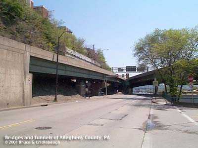
View west from South Tenth St Bridge More detail photos OFFICIAL NAME: Penn Lincoln Parkway East - Interchange 4 - Second Av [mileage-based interchange #1D] SR8002 Ramp M OTHER DESIGNATION: formerly SR8096 LOCATION: Pittsburgh USGS 7.5" Topo Quad - UTM Coordinates: Pittsburgh East - Zone 17; 0585 4476 CARRIES: -- westbound exit from Parkway East [I-376, US22, US30] to Second Av BETWEEN: CROSSES: -- South Tenth St Bridge; Second Av; entrance to Armstrong Tunnel TYPE OF CONSTRUCTION / DESIGN: riveted girder cantilever supported by pinned connections at expansion joints reinforced concrete hammerhead piers LENGTH OF MAIN SPAN: TOTAL LENGTH (including longest elevated ramp): 405 ft HEIGHT OF DECK: YEAR ERECTED / ENGINEER: 1956, PA Dept of Highways ADDITIONAL INFO: This westbound exit ramp delivers traffic from the Parkway East to Second Av just west of the South Tenth St Bridge. The ramp splits from an elevated section of the Parkway where the Baltimore and Ohio Railroad yard was formerly located. For a split second it offers an up-close view of the ashlar masonry of the south portal of the Armstrong Tunnel. The tunnel was completed in 1927 and was one of the last examples of traditional stonework in Pittsburgh public works. Also adjacent to the ramp, a stairway connects Second Av to a pedestrian bridge over the Blvd of the Allies on the Bluff. This stairway is on the site of the Fort Pitt Incline which operated from 1882 to c1900. FIELD CHECKED: INFO SOURCES: Submit info or inquiry - share some facts or ask a question. Introduction -- Nearby Structures Page created: Last modified: 07-May-2001 |
View Larger Map 
| |
| copyright: © Bruce S. Cridlebaugh 1999-2008 All Rights Reserved | |||