| Home > All By Location regional map > Pittsbugh East > Mission St over Quarry St | |||||||||
|
|
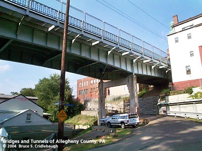
View northeast from Greeley St at Gomer St More detail photos OFFICIAL NAME: Mission Street Bridge OTHER DESIGNATION: Mission St over Greeley and Gomer streets Mission St East pghe586-28 LOCATION: Pittsburgh USGS 7.5" Topo Quad - UTM Coordinates: Pittsburgh East - Zone 17; 0586 4475 CARRIES: Mission St BETWEEN: -- Mission Street Pumping Station -- Sterling Way CROSSES: -- former site of St. Clair Incline; Greeley St; Gomer St TYPE OF CONSTRUCTION / DESIGN: Haunched riveted steel plate girder on concrete bents LENGTH OF MAIN SPAN: TOTAL LENGTH (including longest elevated ramp): 225 ft HEIGHT OF DECK: YEAR ERECTED / ENGINEER: 1939, City of Pittsburgh ADDITIONAL INFO: from the PennDOT Historic Bridges Survey: The 3-span, continuous, 225'-long, built-up thru girder bridge built in 1939 is supported on Moderne-style concrete bents with stepped back columns and brackets. The ashlar abutments appear to date to the previous bridge. The haunched girders have the characteristic greatest depth over the piers where the stresses are greatest. Cantilevered steel stringer sidewalks are supported on metal brackets. The bridge is finished with custom-designed Moderne-style metal railings with balusters repeating the stepped pattern of the bent columns. The continuous design was an important improvement in steel stringer and girder bridges nationally beginning in the late 1920s and early 1930s. In Pennsylvania, the continuous designs appeared somewhat later in the late 1930s and early 1940s when state and municipal engineers adopted the design because of the economy it achieved in comparison to simply supported spans of similar length. The 1939 bridge and its nearly identical companion span (BMS# 0273010003061) are early and complete examples of long-span, handsome architectonic, continuous steel girder bridges designed by the City of Pittsburgh Department of Public Works. The PennDOT Survey incorrectly describes this bridge as a thru girder type; both Mission Street bridges are deck girder bridges. A metal builder's plaque is mounted on the northern railing near South 18th Street:
The 1872 Hopkins plat map shows Jos. Keeling and Co. coal railroad and incline site running up the center of South 21nd St (originally Railroad St), following Quarry St to St. Patrick St. The incline does not appear on the 1916 edition of the map and the valley is occupied primarily by the Sankey Brick Works. Both maps show Ormsby and Phillips heirs owning much of the hillside with a large lot owned by Phillips having a long narrow strip or easement down the center of South 21st St; today the street retains its unusually wide path all the way across the South Side Flats to the Monongahela River. This area is one of those noted for its extremely steep, narrow streets. The original plot plans seem so perfectly logical and neatly arranged on paper -- obviously laid out on paper without much regard to the true lay of the land. The J. H. Page Plan of lots appears on the 1872 Hopkins map as a neat, nearly rectangular grid between Eleanor St and an unnamed Sterling Way. From the bottom to top the cross streets include Lincoln (for the recently assassinated President), Mission, Chestnut, Holt, and Spruce streets. Although the names do not appear until later maps, present-day Gomer St is Grant St (for the then-current President) angling down to the ironically named Greeley St -- perhaps named for Horace Greeley, founder of the New York Tribune and anti-slavery activist whom Grant defeated in his 1872 re-election to a second term. Greeley died almost immediately afterward. (Lincoln [Lebanon, then Leticoe] and Grant [Gomer] streets were renamed when Birmingham was annexed by the city of Pittsburgh; their names changed to prevent duplication.) Further evidence of the over-optimistic attempt to lay an orderly grid over the South Side Slopes is evident when one visits the area: Eleanor St between Leticoe and Holt includes one of Pittsburgh famous paper-street stairways with 282 steps. Sterling Way, at least, includes a narrow roadway to accompany its most of its steps (three sets totaling 394 -- over 1,000 ft rise). At first thought it seems Mission St would have been named in relation to the churches and monestary on the surrounding hillside. Present day Mission St extends much farther than its original one block within Page's Plan. Its origin as a tiny cross street seems to indicate the name is unrelated to those other churches. The 1916 map shows bridges at each of the ravines: South 21st St and Greeley St. The stonework below each is cut ashlar blocks. Although the bridges are nearly identical in design, the South 21st St substructure contractor is listed as Booth and Flinn (which had the lion's share of masonry contracting for the city at the time), and Edward Kean at Greeley St. The stone abutments appear to be remnants from the older bridges. In setting the abutment bearings for the present bridge, sections of the top course of stones were cut way. Also appearing on the 1916 map is the St. Clair Inclined Railway. The St. Clair Incline operated from 1886 to 1935 with a lower station on Josephine St near South 22nd St and an upper station on Salisbury St between Fernleaf and Sterling streets in the former township of St. Clair. The track ran along the western side of Greeley St; the course remains unoccupied by buildings. One of the interesting design features of each bridge is the apparent echoing of the Cathedral of Learning in Oakland. The PennDOT Survey notes the style as Moderne, which for 1939 is appropriate. Yet, the railing design is also found on the city's 1940 Charles Anderson Bridge connecting the Blvd of the Allies with Schenley Park. The University of Pittsburgh's stone tower was just being completed in 1937 and is a prominent landmark visible from all three bridges. From the distant viewpoint of each bridge, the Cathedral silhouette is simplified into forms found repeating on the metal railing and in the concrete bent substructure. view page - Mission Street Bridge over South 21st Street FIELD CHECKED: 10-Jul-2004 INFO SOURCES: field check, PennDOT Historic Bridges Survey; Hopkins plat maps (1872, 1916); Robert Regan, "The Steps of Pittburgh" Submit info or inquiry - share some facts or ask a question. Introduction -- Nearby Structures Page created: Last modified: 12-Jul-2004 |
View Larger Map 
| |||||||
| copyright: © Bruce S. Cridlebaugh 1999-2008 All Rights Reserved | |||||||||