| Home > All By Location regional map > Pittsbugh East > Parkway East over Saline St | |||
|
|
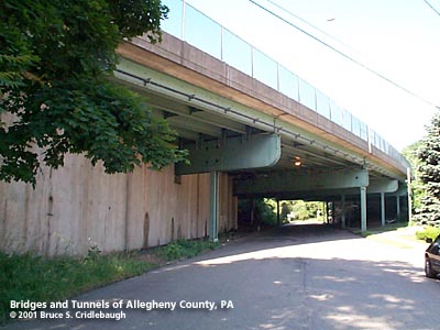
View northeast on Saline St More detail photos OFFICIAL NAME: Saline St Bridge Penn Lincoln Parkway East #7 763-3, 824+56 OTHER DESIGNATION: LOCATION: Pittsburgh USGS 7.5" Topo Quad - UTM Coordinates: Pittsburgh East - Zone 17; 0589 4475 CARRIES: -- Parkway East [I-376, US22, US30], six lanes divided BETWEEN: CROSSES: -- Saline St TYPE OF CONSTRUCTION / DESIGN: steel girder stringers on riveted plate girder bents with girder columns LENGTH OF MAIN SPAN: 6 spans of 68 ft, 1 span of 60 ft TOTAL LENGTH (including longest elevated ramp): 472 ft HEIGHT OF DECK: 14 ft clearance [92 ft deck width] YEAR ERECTED / ENGINEER: 1951, PA Dept of Highways ADDITIONAL INFO: This structure features cantilevered bent caps, unique to this location along the Parkway. Because of the angle at which the highway crosses Saline St, the cantilevers allowed the columns to be set back from the street and with the exception of the eastern abutment, skews are avoided. Five spans carry the highway over the street and an intersection at Levene St. The overpass appears like a gate separating a few dozen homes on three streets -- a few hundred feet before lower Saline St dead ends at the highway. The 1904 Hopkins plat map shows Saline St as Forward Av. Today Forward Av descending from the Squirell Hill neighborhood has been redirected to pass below the western portal of the Squirrel Hill Tunnel. Saline St has been cut into two sections. The western section follows the low line of the Four Mile Run valley; the eastern section reappears beyond the Parkway interchange at Squirrel Hill. When this route was continuous it was also known at Salt Works Rd as it led to the salt works on Nine Mile Run on the Monongahela River. FIELD CHECKED: INFO SOURCES: fieldcheck; 1953 PA Dept of Highways report Submit info or inquiry - share some facts or ask a question. Introduction -- Nearby Structures Page created: Last modified: 25-Jul-2001 |
View Larger Map 
| |
| copyright: © Bruce S. Cridlebaugh 1999-2008 All Rights Reserved | |||