| Home > All By Location regional map > Pittsbugh East > Parkway East Int - Edgewood / Swissvale | |||
|
|
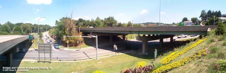
Ramp E (left) and Parkway East over Braddock Av More detail photos OFFICIAL NAME: Penn Lincoln Parkway East - Interchange 9 - Edgewood / Swissvale [mileage-based interchange # 7] Braddock Av Interchange SR8010 OTHER DESIGNATION: LOCATION: Pittsburgh, Edgewood, Swissvale USGS 7.5" Topo Quad - UTM Coordinates: Pittsburgh East - Zone 17; 0593 4475 [eastern portion in 0594 4475] CARRIES: -- eastbound entrance to Parkway East [I-376, US22, US30] from Braddock Av [Green Belt] -- eastbound entrance to Parkway East [I-376, US22, US30] from Monongahela Av -- eastbound exit from Parkway East [I-376, US22, US30] to Monongahela Av, Braddock Av [Green Belt] and Greendale Av [Ramp B] -- westbound entrance to Parkway East [I-376, US22, US30] from SB Braddock Av [Green Belt] -- westbound entrance to Parkway East [I-376, US22, US30] from NB Braddock Av [Green Belt], New St, and Swissvale Av [Ramp E] -- westbound exit from Parkway East [I-376, US22, US30] to Braddock Av [Green Belt] BETWEEN: CROSSES: -- Parkway mainline crosses Braddock Av [Green Belt] (station 970+61) -- Parkway mainline crosses Ramp B (station 965+48) -- Ramp B: passes under mainline of Parkway and crosses Braddock Av [Green Belt], carrying eastbound exit to Braddock Av and Greendale Av -- Ramp E: crosses Braddock Av [Green Belt], carrying eastbound entrance northbound Braddock Av, New St, and Swissvale Av (station 4+92) TYPE OF CONSTRUCTION / DESIGN: -- Parkway mainline over Ramp B: 3-span steel girder, simple spans on concrete hammerhead bents [16 stringers wide] -- Parkway mainline over Braddock Av: 3-span steel girder with suspended center span carried by pinned hinges on concrete hammerhead bents [12 stringers wide] -- Ramp B over Braddock Av: steel riveted plate girder simple span on concrete abutments [8 stringers wide] -- Ramp E over Braddock Av: 3-span steel girder with suspended center span carried by pinned hinges on concrete hammerhead bents [6 stringers wide] LENGTH OF MAIN SPAN: -- Parkway mainline over Ramp B: 2 end spans of 50 ft, center span of 66 ft -- Parkway mainline over Braddock Av: 2 end spans of 58 ft, center span of 86 ft -- Ramp B over Braddock Av: 104 ft -- Ramp E over Braddock Av: end span of 58 ft, center span of 87 ft, end span of 56 ft TOTAL LENGTH (including longest elevated ramp): -- Parkway mainline over Ramp B: 170 ft -- Parkway mainline over Braddock Av: 185 ft -- Ramp B over Braddock Av: 104 ft -- Ramp E over Braddock Av: 170 ft est HEIGHT OF DECK: -- Parkway mainline over Ramp B: 14 ft clearance [79 ft road width] -- Parkway mainline over Braddock Av: 16 ft clearance [64 ft road width] -- Ramp B over Braddock Av: 14 ft clearance -- Ramp E over Braddock Av: 14 ft est [30 ft road width] YEAR ERECTED / ENGINEER: 1952, PA Dept of Highways ADDITIONAL INFO: The 2.5 mile section of the Parkway from the Commerical St viaduct to Ardmore Blvd was constructed by Adam Eidemiller, Inc, of Greensburg, PA. Work began January 1950 and concluded November 1952. The interchange was fitted into a natural valley which once brought Forward Av from Squirrel Hill (at Commericial St) along an arm of the Nine Mile Run valley. The intersection of Forward, Monongahela and Braddock Avenues was once near the Parkway mainline bridge over Ramp B. Today the only sign of the old road locations is an abandoned brick section of old Braddock Av, still holding parallel sets of streetcars tracks, descending to an ramp embankment. The Parkway east of Braddock Av follows an extension of the Nine Mile Run valley toward the Brinton Av Bridge. This hollow is shown on old plat maps as being the location of an old short line railroad serving two inclines for coal, clay and stone. George Westinghouse is shown as landowner for much of the property on the 1904 G. H. Hopkins map. The Union Switch and Signal Company established a large factory on the Pennsylvania RR with the Borough of Edgewood cleverly drawing its boundaries to include the land on it tax rolls though it is much closer to the Swissvale business district. Nearly 100 years later, the benefits would continue as the property was converted to the Edgewood Town Centre shopping plaza. When the route for the Parkway was laid, it carefully avoided the important Union Switch facility and curved around its northern edge. Within the curving onramp between Greendale Av and Swissvale Av a PA Historical Commission marker commemorates the writer Jane Grey Swisshelm (1815-1884), a pioneering female journalist and anti-slavery activist. Her family owned a large tract of land here and the Borough of Swissvale takes its name from her family. The Pennsylvania RR laid its Pittsburgh-Philadelphia line nearby in 1854, sparking the growth of the area. The Braddock Av interchange includes four bridges -- one simple span and three 3-span structures. The Parkway mainline crosses Ramp B, the westbound exit to Monongahela, Greendale and Braddock Avenues. The ramp veers right with a lane splitting to the right toward Monongahela Av; the other lane curves left to pass under the Parkway mainline at station 965+48. The three simple spans include two 50 foot end spans and a 66 foot center span. The deck carries two highway lanes in each direction and the merging end of the Ramp E westbound entrance. Ramp B begins to rise as it approaches Braddock Av to the north. It crosses Braddock Av on a 104 foot riveted plate girder simple span. The ramps immediately splits into two: the left branch meeting Braddock Av, the right branch extending into the former location of about 20 homes which once lined the north side of Greendale Av. The homes on the south side of Greendale face a concrete wall which gradually tapers as the ramp and street become one. The Parkway mainline and its parallel Ramp E cross Braddock Av on a pair of three-span bridges which feature a center span suspended by pinned hinges. This type of hinge was later (1956) used on the viaduct which carries the Parkway East over the former B&O RR yard near Second Av in downtown Pittsburgh. The interchange was rehabilitated in October 1981. FIELD CHECKED: 09-Jul-2001 INFO SOURCES: fieldcheck; PA Dept of Highways, "Penn Lincoln Parkway", 1953 Submit info or inquiry - share some facts or ask a question. Introduction -- Nearby Structures Page created: Last modified: 26-Jul-2001 |
View Larger Map 
| |
| copyright: © Bruce S. Cridlebaugh 1999-2008 All Rights Reserved | |||