|
View north
More detail photos
OFFICIAL NAME:
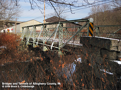
Dorrington Road Bridge
OTHER DESIGNATION:
Dorrington Rd over Robinson Run
LOCATION:
Ewingsville, Collier Twp.
USGS 7.5" Topo Quad - UTM Coordinates:
Pittsburgh West - Zone 17; 0575-4471
CARRIES:
South Ewing St, aka Dorrington Rd
BETWEEN:
-- South of Noblestown Rd
-- Cluxton St, Dorrington Rd
CROSSES:
-- Robinson Run
TYPE OF CONSTRUCTION / DESIGN:
Pin-connected Pratt pony truss
Vertical endposts
Cast and wrought iron
Wooden deck with asphalt overlay
LENGTH OF MAIN SPAN:
60 ft
TOTAL LENGTH (including longest elevated ramp):
60 ft
HEIGHT OF DECK:
19 ft wide
15.74 ft wide, roadway
YEAR ERECTED / ENGINEER:
1888, Pittsburgh Bridge Company, Pittsburgh, PA
F.L. Garlinghouse, Engineer, C.E., A.S.C.E., Pittsburgh Bridge Co.
ADDITIONAL INFO:
Demolished August 2009.
One of the oldest bridges in Allegheny County, this bridge was opened in 1888 -- Allegheny County's centennial year. A rare example of cast and wrought iron Pratt pony truss with vertical endposts. One of only 15 cast and wrought iron truss bridges remaining in PA as of 1997 PA Historic Bridge survey. Last remaining cast and wrought iron truss in PennDOT District 11 (SWPA); one of five iron truss bridges in District; only remaining iron pony truss in District.
Carnegie Steel supplied the materials for the superstructure. The "CARNEGIE" brand is visible on several truss members.
Pittsburgh Bridge Company was established in 1878. Its office was between
36th and 38th streets at the Allegheny Valley Railroad in Pittsburgh's Strip District. By
1909, their office had moved to the Hartje Building on Wood St (now part of
Point Park College). In addition to bridges (a few of which still stand in
Lawrence County and elsewhere), PBC supplied the beams for floor joists and
roof trusses for Vanderbilt's Biltmore House.
This was probably the last Pittsburgh Bridge Co. structure in Allegheny County.
Engineer, Fred L. Garlinghouse edited "Standard Steel Construction" from Jones & Laughlin Steel Company. He was in the 1871 class at Rensselaer Polytechnic Institute and listed as Assistant Engineer on New York and Erie Railroad in Buffalo, NY.
Quoted from phlf.org:
According to December 2006 data from the Federal Highway Administration:
- 3.3% of PA bridges are trusses (2006), down from 5.5% in 1992; a loss of 40% (482 bridges)
- 2.2% of bridges nationally are trusses, down from 4.3% in 1992; a loss of 47% (11,380 bridges)
- 21 states have 100 or fewer truss bridges; 5 states have 25 or fewer truss bridges
- If that trend continues, all historic truss bridges that have not been preserved or rehabilitated will be demolished within the next 16 years
- According to the PA Historic Bridge Inventory, 12% of truss bridges surveyed in 1997 were built before 1890 and 30% were built before 1900
- "Over half the historic bridges identified by statewide surveys have disappeared over the last twenty years" - Winter 2003 Preserving Pennsylvania Newsletter
Expert Evaluation:
Eric DeLony, former Chief of the Historic American Engineering Record (HAER) and author of Landmark American Bridges.
On January 31, 2007, Eric made the following evaluation regarding the Dorrington Road Bridge:
"Despite the wealth of historic bridges in Pennsylvania, I'm confident the bridge will be at the top of the list regarding its value, significance, condition and preservation potential. The outriggers (buttresses) look like they might have been added to increase lateral stability, but this was well done, and in my view doesn't diminish its integrity. The bridge has many things in its favor for preserving: significance, condition and relatively short span a structure easily moved to another location."
- - - -
Quoted from wmeriddle.com:
Ewing Plantation
William A. White, [Pittsburgh] Press Staff Writer
The plantation of pioneer James Ewing once flourished at [the] Ewingsville, Collier Township settlement better known now as Fort Pitt. (Fort Pitt Rd still ascends the hill north of Ewingsville.) It was a sprawling farm that spread over a 1,000 acres westward for two miles from the borderline of what is now Carnegie Borough.
Slave labor worked over the land, cleared it for cultivation before the Revolutionary War, when the area was still part of Virginia.
Born in the almost-new America in 1730 at Cecil, Maryland, James Ewing came west of the mountains seeking a homeland, as many others of the East were doing when it appeared Indian dangers were over. He established claim to the land in 1770, [and] soon had a grist mill operating on Robinson Run which might have been the first such mill in what was eventually to become Allegheny County.
In time he is said to have built a distillery, not an uncommon thing for landowners to do before the Whisky Insurrection.
Bells Explored Area About That Time. Carnegie had not yet been born, but the Bells from Virginia, who has explored the area in 1769, settled in the same year of Ewing's arrival on opposite sides of Chartiers Creek to sow the seeds from which grew the boroughs of Chartiers and Mansfield. The two were combined in later years and named Carnegie in honor of Andrew Carnegie.
Gabriel and Isaac Walker came into the Robinson Run Valley two years after Ewing to take up 2000 acres west of the Ewing tract and from their coming Walkers Mill grew.
The Ewing land extended from the border of Chartiers on the west side of Chartiers Creek to the place that became Walkers Mill.
As did most all emigrants from the southern colonies, Ewing brought with him a coterie of slaves and used them to establish his new estate. They felled the trees for the timber that built the first Ewing log house and the Ewing blockhouse which was to become a blessing to the area a dozen years later.
Freed Slave Established Camp Hill. One of these slaves, known as Botswain, was because of his fidelity freed from bondage and established a comfortable home at what became Camp Hill, a mile west of the railroad station at Carnegie.
The Ewing log house eventually grew into a mansion on the hill to the north of the McDonald-Oakdale Road it has long been known as Noblestown Road from which there is a view of the entire valley.
Charles M. Ewing, (former) director of Historical Collections at Washington and Jefferson College, who was at one time a railroader in Carnegie, recalls the old home, which was destroyed by fire several years ago. Its mammoth kitchen fireplace, he says, burned 10-foot logs which were hauled into the room through a door especially constructed to permit passage of a horse.
Mr. Ewing has among his collections the original manuscript of the "Narrative of the Walker Family," written by Isaac Walker III, which is the story of the settlement of the area by the Walker and Ewing families, which were cemented by marriages.
In it is the story of an Indian attack on the Walker family in 1782, probably the last Indian attack in Allegheny County.
FIELD CHECKED:
INFO SOURCES:
field check, historicbridges.org; phlf.org
Submit info or inquiry - share some facts or ask a question.
Introduction --
Nearby Structures
Page created:
18-Nov-2008
Last modified:
23-Nov-2008
|
View Larger Map

|