| Home > All By Location regional map > Pittsburgh West > McKees Rocks Bridge | |||||
|
|
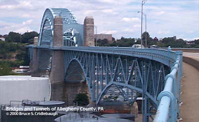
View north of channel span 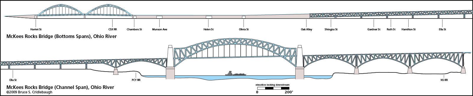
Elevation drawing looking downstream More detail photos OFFICIAL NAME: McKees Rocks Bridge - Ohio River channel span crossing view page - Western section over McKees Rocks "Bottoms" OTHER DESIGNATION: Historic American Engineering Record (HAER) survey number PA-445 pghw580-4 LOCATION: Pittsburgh - McKees Rocks USGS 7.5" Topo Quad - UTM Coordinates: Pittsburgh West - Zone 17; 0580 4480 CARRIES: Blue Belt, SR3104; two lanes each direction Pedestrian walkways on outside of both upstream and downstream trusses upstream sidewalk closed BETWEEN: -- Ohio River Blvd [PA65] at Termon Av Approach -- Island Av [PA51] (McKees Rocks) CROSSES: -- NS RR -- Ohio River at Mile 3.3 -- Pittsburgh, Chartiers and Youghiogheny RR, Pittsburgh Industrial RR; Agnes St (Warren trusses directly above); Olivia St ped underpass; Helen St; Munson Av; Chambers St; CSX RR [PLE RR]; PCY RR; Harriet St TYPE OF CONSTRUCTION / DESIGN: steel trussed through arch and others LENGTH OF MAIN SPAN: 750.0 ft TOTAL LENGTH (including longest elevated ramp): 7,300 ft est HEIGHT OF DECK: 100.6 ft Emsworth Dam normal pool level 710 ft YEAR ERECTED / ENGINEER: 1931, County of Allegheny Vernon R. Covell, Chief Engineer Alfred D. Nutter, Engineer of Bridge Design Penn DOT, current owner ADDITIONAL INFO: view page - McKees Rocks Bridge western section over Helen Street and CSX RR view page - McKees Rocks Bridge -- Historic American Engineering Record The McKees Rocks Bridge is a complex string of structures stretching nearly 1.5 miles across the wide, flat valley of the Ohio River. The focal point of the group is the 750-foot two-hinged trussed arch river span. Reminiscent of New York's Hell Gate Bridge by Gustav Lindenthal (builder of the Smithfield Street Bridge), the top chord of the arch flattens out to meet the massive stone entrance pylons. Built during a peak in Allegheny County bridge construction, this structure is one of the most self-consciously monumental bridges in the county. The West End Bridge, about two miles upstream, and the Westinghouse Bridge, in East Pittsburgh, also show intentions of grand designs. Stanley L. Roush, architect for the City of Pittsburgh, shows his role in dressing the McKees Rocks Bridge in tall stone pylons. The top of each entry pylon includes the Seal of Allegheny County in stone relief. Carved stone panels face out from the portals:
Below the Seal of Allegheny County on the northeastern pylon, a carved stone panels faces the river channel:
But the river span makes up only 1/10 of the length of this group which is practically a pattern book of bridge types. It includes, from east to west: a 77-foot deck girder, three cantilever spandrel-braced deck arches (334 ft, 324 ft, 338 ft), 750-foot river span, another cantilever spandrel-braced deck arch (340 ft) and its counterbalancing deck truss span (194 ft), eight Warren deck trusses (each about 163 ft), an elevated concrete section of 1,145 ft which includes a pedestrian underpass at Olivia St, a trio of two-lane vehicle underpasses at Helen St, Munson Av and Chambers St, a pair of crescent trussed through arches (300 ft each) crossing the rail yards, a single lane vehicle underpass at Harriet St, finally touching down in a ramp which meets Island Av in McKees Rocks. The string of structures is so long and complex that the western section threading its way through McKees Rocks Bottoms is described on its own page. Travelling toward McKees Rocks, the roadway bends about 30 degrees to a nearly direct westward course just before reaching the eight Warren deck trusses. In doing so, it skirts the northern tip of the remains of a prehistoric Native American mound. The mound has been altered over the years since the European settlers arrived, and today it is topped with oil storage tanks. The mound was built up as an extension of the natural exposed rock formation which gave the town its name. The eastern tip still shows an exposed rock outcropping, but this area has been used as a stone quarry and storage facility; its natural beauty and prominence as a landmark has been lost. When the bridge opened in 1931, it was linked to the new Ohio River Boulevard by a traffic circle at Termon Av. The ORB was one of four major road building projects which were designed as tree-lined parkways. The others in the same bond issue were Saw Mill Run Blvd, Allegheny River Blvd and Mosside Blvd (Monroeville, then Patton Twp). All of these roads except Mosside Blvd were given bridges with ornamental railings, rows of shade trees and entrance pylons with carved stone reliefs depicting historical scenes from Pittsburgh's past. FIELD CHECKED: 06-Jul-2000 INFO SOURCES: USACE Ohio River Nav. Charts Submit info or inquiry - share some facts or ask a question. Introduction -- Nearby Structures Page created: Last modified: 26-Sep-2000 |
View Larger Map 
| |||
| copyright: © Bruce S. Cridlebaugh 1999-2008 All Rights Reserved | |||||