| Home > All By Location regional map > Pittsburgh West > California Av over Jacks Run | ||||
|
|
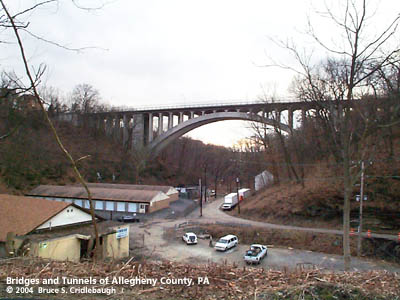
View west from Brighton Rd (downstream to Ohio River) More detail photos OFFICIAL NAME: Bridge Number 1, Jack's Run OTHER DESIGNATION: Jacks Run Bridge New High Bridge California Av over Jacks Run pghw580-1 LOCATION: Pittsburgh / Bellvue USGS 7.5" Topo Quad - UTM Coordinates: Pittsburgh West - Zone 17; 0580 4482 CARRIES: California Av (Pittsburgh); California Av Extension connecting to Lincoln Av (Bellvue) BETWEEN: -- Winhurst St (Pittsburgh) -- Margaretta Av (Bellvue) CROSSES: -- Jacks Run -- Farragut St TYPE OF CONSTRUCTION / DESIGN: concrete deck arch LENGTH OF MAIN SPAN: 770 ft TOTAL LENGTH (including longest elevated ramp): 320 ft HEIGHT OF DECK: 150 ft est YEAR ERECTED / ENGINEER: 1923-24, County of Allegheny ADDITIONAL INFO: Early maps (1872, 1876, 1886) show New Brighton Rd as the through road from Pittsburgh to points down the Ohio River. The river bank, a more level and seemingly easier route, was used by the Pittsburgh & Fort Wayne Railroad. The railroad located stations at Woods Run and Jacks Run. These streams carved two deep, wide valleys which lead up from the Ohio River and cut the relatively flat plateau into Bellevue -- incorporated in 1867 from a portion of Ross Township -- and the city neighborhoods of Brighton Heights and Marshall-Shadeland. The flat river plain of the North Side rises very gradually northward from the Manchester neighborhood. California Avenue makes use of the steady grade to gain nearly 200 feet in elevation before reaching, first, the obstacle of Woods Run valley, then Jack's Run valley. The older through route, New Brighton Rd, snaked around the eastern backside of this rise -- climbing over, around and under the various hills and valleys. It ascends from the Jack's Run valley to meet Lincoln Av in Bellevue a few blocks north of the High Bridge location. At the close of the 19th century, the hilltop plateaus were laid out into lots for residential development. Piece by piece, street railways connected downtown Pittsburgh with this area -- still the separate city of Allegheny until 1907. A memoir by Henry David Ford recalls his 1889 purchase and renovation of the Pleasant Valley Street Railway, which became the first successful electric-powered streetcar line. In addition to all new rolling stock to replace the horsecars, the company constructed new lines including a High Bridge on California Avenue over Jack's Run. The steel bridge on trussed bents, about 150 above the valley floor, was noted by Ford as being 6 feet higher than the Brooklyn Bridge. A short, curving extension of California Av was built in Bellevue to join the streetcar bridge with Lincoln Av. The High Bridge was one of many infrastructure improvements, including the opening, grading and paving of streets, which were commonly undertaken by the street railway companies as part of their charter. As automobile traffic increased, the earlier bridges were insufficient to handle the growing volume. Typically the bridges which had been built by private companies were replaced by new structures erected as public works. In 1922, in preparation for the replacement of the old streetcar bridge, Eichleay Engineers jacked up the old steel bridge and moved the 750 foot long structure a few dozen feet downstream in a single day -- reopening it for continued traffic while the County built a new concrete arch bridge. The temporary piers are still in place in the woods below. Along the right bank of the Ohio River, communities sprang up along the old road to the town of Beaver, which was also known as Brighton. The road is thus known by various names along the way. The town of Bellevue was incorporated two years after the end of the Civil War; its main street portion of Beaver Road was named in honor of President Abraham Lincoln. Coincidentally in 1913, the Lincoln Highway Association routed its coast-to-coast highway along Lincoln Av though Bellevue. The completion of the new concrete arch bridge was hailed as a great improvement in the Lincoln Highway's course through Pittsburgh. Yet in 1927, a mere three years after the new bridge opened, the Lincoln Highway was re-routed south of the Ohio River as it headed west from downtown Pittsburgh. from the PennDOT Historic Bridges Survey: The viaduct carries a 2 lane street and sidewalks over stream and local road on the Pittsburgh-Bellevue line. It appears to be within a potential historic district composed predominantly Queen Anne and Colonial Revival-style residences from 1880 to 1930 located on both sides of the Jacks Run ravine. The architecturally significant district developed as a railroad/streetcar suburb of Pittsburgh. The only notable infill buildings are four post-WW II residences near the east end of the bridge. The bridge, built within the period of significance, would contribute to the historic district. The 15-span, 770'-long bridge built in 1924 is composed of a 320'-long, ribbed, open spandrel arch span and 14 concrete slab approach spans. It is supported on concrete abutments and concrete column and cap beam bents. Plain spandrel columns support concrete floorbeams and a concrete slab deck. The bridge has Allegheny County standard design steel railings. Obelisks topped by eagles are at each corner. The bridge, with its arch crown approximately 140' from the ground, is a long and well-proportioned example of its type and design. It is the most complete of the 13 identified examples in Allegheny County from 1912 to 1950. Many examples have lost their original railings and architectural features. When built, the bridge was the longest of all of the county's open spandrel arch spans. The public works department would continue to push the limits of the technology, eventually culminating in the world's longest example, the George Westinghouse Bridge (1931). The bridge illustrates well the aesthetic appeal of the open spandrel arch type and design in urban settings. The individual historic and technological significance of this example is further enhanced by its setting in an 1880-1930 residential area that appears to be a potential historic district. A metal builder's plaque is attached to a stone pylon at each end of the bridge:
A metal commemorative plaque is attached to a stone pylon at each end of the bridge:
The Wilksboro Avenue Footbridge, a 400 foot long trestle, crosses a nearby branch of the Jack's Run Valley near the intersection of California Av and Oswald St. FIELD CHECKED: 03-Mar-2004 INFO SOURCES: field check; PennDOT Historic Bridges Survey; "The genealogy of the Henry family by D. F. Henry", 1916; Eichleay Engineers Submit info or inquiry - share some facts or ask a question. Introduction -- Nearby Structures Page created: Last modified: 14-Jun-2004 |
View Larger Map 
| ||
| copyright: © Bruce S. Cridlebaugh 1999-2008 All Rights Reserved | ||||