| Home > All By Location regional map > Pittsburgh West > Corliss Tunnel | |||
|
|
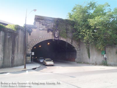
Northern portal at West Carson St More detail photos OFFICIAL NAME: Corliss Street Tunnel OTHER DESIGNATION: Corliss Tunnel LOCATION: Pittsburgh USGS 7.5" Topo Quad - UTM Coordinates: Pittsburgh East - Zone 17; 0581 4478 CARRIES: Corliss St (2 lanes) sidewalk on west side BETWEEN: -- West Carson St [PA51, Yellow Belt] -- Rudd St UNDER: Norfolk Southern RR [former PCCStLRR; Panhandle Div, PRR; Conrail] TYPE OF CONSTRUCTION / DESIGN: concrete lining, coffered ceiling vault, ceramic brick below spring line through filled embankment northern portion of vault (320 ft est): elliptical arch; southern portion of vault (110 ft est): segmental arch TOTAL LENGTH: 420 ft est OTHER DIMENSIONS: 35 ft wide (est) 20 ft high (est) at top of arch rise YEAR OPENED / ENGINEER: 1914, City of Pittsburgh Stanley L. Roush, architect D. N. Sprague, chief engineer ADDITIONAL INFO: A group of three railroad companies were formed to construct a line from Pittsburgh westward into Ohio as a rival to the Baltimore & Ohio. In 1849, the Pittsburgh & Steubenville was incorporated to construct the portion to the Virginia (now WV) line [see Kobus for more info]. The line was completed in 1865 including the tunnel under Grant's Hill in downtown Pittsburgh which provided the connection with the Pennsylvania RR. Construction costs and delays resulted in the foreclosure of the P&S and take over by the Pan Handle Railway Co in 1868. Further consolidations led to the formation of The Pittsburgh, Cincinnati, Chicago & St. Louis Railroad which ultimately became the Panhandle Division of the PRR. The P&S RR crossed the Panhandle Bridge and followed the left bank of the Monongahela River on a shelf below Mt. Washington and then along the Ohio River to Corks Run. Passing Nimick Station (today the site of the Corliss Tunnel) the railroad followed Corks Run southward near the farm of William Sheraden. The P&S RR passed the speculative plat of Aschenaz (The borough was incorporated in 1894 as Sheraden. The station and post office were renamed Corliss by the PRR in 1918 because there was already another station named Sheriden.) and entered the 1865 Cork Run Tunnel (rebuilt in 1996 as the Berry St Tunnel Port Authority's on the West Busway. In 1890 the Ohio Connecting RR was built across Brunot Island and southward along Chartiers Creek. The connection between the Panhandle (P&S) and the OCRR sections of the PRR was completed about 1905 -- further constricting the end of the Corks Run valley. In 1897, the Pittsburgh, Crafton and Mansfield (Carnegie) Railway was chartered to build a streetcar line through Sheraden. The Panhandle RR viaduct and the need for crossing the railroad below grade impeded their progress to link Corks Run Public Rd (Corliss St) with Robinson Township Turnpike (West Carson St). Until the problem was resolved traffic was forced to use the Steubenville Pike (Steuben St). A few hundred feet west, the tiny underpass which squeezes Glen Mawr Rd under the OCRR branch may give some indication of what the old outlet of Corks Run Rd may have looked like. When the Borough of Sheraden voted to become part of the City of Pittsburgh in 1907 there were numerous in public works. The construction of the "Archway to Sheraden" -- the Corliss Street Tunnel -- was started December 15, 1913 and completed on the last day of 1914. The stone tablet above the city escutcheon on the West Carson St portal says the tunnel was "Erected MCMXIV" (1914). But the bronze plaque closer to street level reads 1916. The Pittsburgh Railways laid a double streetcar track through the tunnel. Small parts of the now covered rails and brick surface may be seen though holes in the asphalt inside the tunnel. The total length of the tunnel is approximately 420 feet. The shape of the ceiling vault changes: the 320 foot section nearest West Carson St is an elliptical arch, while the remaining 110 feet on the Sheraden end is a circular segmental arch and therefore has a higher rise, perhaps 5 feet. The West Carson portal is the more ornate of the two, featuring stone carvings: eagles at the parapet, lion heads at the hauches and the city escutcheon with festoons above the arch center. The Sheraden portal includes the name of the tunnel in terra cotta tiles and a single carved stone lion head at the keystone of the arch. Both portals mimic a rusticated archivolt -- what appears to be indivdual stone voussoirs outlining the arch opening are meerly formed in concrete. There are no mechanical means of ventilation and no vent stacks. Mounted at the West Carson St portal, a plaque reads:
In 2000-1 the Port Authority built a 500 foot long bridge to carry the Airport West Busway over the NSRR (Conrail) tracks and above the Corliss Tunnel. The Busway uses the right of way of the Panhandle RR to Carnegie. The stone retaining wall on West Carson St west of the Corliss Tunnel and the vegetation on the embankment was removed, leaving the tunnel portal partially re-exposed. FIELD CHECKED: 30-Aug-2001 INFO SOURCES: Kobus and Consoli, "The Pennsy in The Steel City" and "The Pennsylvania Railroad's Golden Triangle"; DeDe Palombi and Diane Smihal, "History of Sheraden" Submit info or inquiry - share some facts or ask a question. Introduction -- Nearby Structures Page created: Last modified: 30-Aug-2001 |
View Larger Map 
| |
| copyright: © Bruce S. Cridlebaugh 1999-2008 All Rights Reserved | |||