| Home > All By Location regional map > Pittsburgh West > California Av over Woods Run | |||||||||||||||
|
|
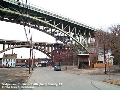
View west from Eckert St: McAfee Bridge in foreground; Ohio River Blvd concrete arch bridge beyond More detail photos OFFICIAL NAME: Robert McAfee Bridge OTHER DESIGNATION: California Av over Woods Run pghw581-4A LOCATION: Pittsburgh USGS 7.5" Topo Quad - UTM Coordinates: Pittsburgh West - Zone 17; 0581 4480 CARRIES: California Av BETWEEN: -- Bainton St -- Forsythe St CROSSES: -- Eckert St; McClure St; Woods Run (covered) TYPE OF CONSTRUCTION / DESIGN: single-hinged deck arch LENGTH OF MAIN SPAN: 380 ft TOTAL LENGTH (including longest elevated ramp): 642 ft HEIGHT OF DECK: YEAR ERECTED / ENGINEER: 1928, City of Pittsburgh ADDITIONAL INFO: The bridge connects Pittsburgh city neighborhoods of Brighton Heights to the north and Marshall-Shadeland. It is nearly parallel to an adjacent concrete arch bridge built by the County of Allegheny as part of Ohio River Boulevard, completed in 1931. The 1872 Hopkins map shows the hilltop where the north end of the bridge lands as Mt. Hope, owned by Leckey. Both of these names survive as street names nearby. Early maps (1872, 1876, 1886) show New Brighton Rd as the through road from Pittsburgh to points down the Ohio River. The river bank, a more level and seemingly easier route, was used by the Pittsburgh & Fort Wayne Railroad. The railroad located stations at Woods Run and Jacks Run. These streams carved two deep, wide valleys which lead up from the Ohio River and cut the relatively flat plateau into Bellevue and the city neighborhoods of Brighton Heights and Marshall-Shadeland. The flat river plain of the North Side rises very gradually northward from the Manchester neighborhood. California Avenue makes use of the steady grade to gain nearly 200 feet in elevation before reaching the obstacle of Woods Run valley. The older through route, New Brighton Rd, snaked around the eastern backside of this rise -- climbing over, around and under the various hills and valleys. At the close of the 19th century, the hilltop plateaus were laid out into lots for residential development. Piece by piece, street railways connected downtown Pittsburgh with this area -- still the separate city of Allegheny until 1907. A 1926 photo shows the dismantling of the first bridge at this location -- a high bridge on trussed bents -- constructed for the streetcars. Such infrastructure improvements, including the opening, grading and paving of streets were commonly undertaken by the street railway companies as part of their charter. As automobile traffic increased, the earlier bridges were insufficient to handle the growing volume. Typically the bridges which had been built by private companies were replaced by new structures erected as public works. A 1926 City of Pittsburgh bond issue included $550,000 for the construction of this bridge carrying California Avenue over the Woods Run Valley. A carved stone builder's plaque is mounted on the inside wall at the northern portal:
The bridge's namesake, Robert McAfee, came to America from Ireland in 1868 and was employed as a shipping clerk for Lewis, Oliver & Phillips, manufacturer of nuts, bolts and small hardware. In 1871, he moved to the company's ironworks near the outlet of Wood's Run into the Ohio River, where he became manager in 1878. He left that firm in 1892 to become the Director of Public Works for the city of Allegheny -- later incorporated into Pittsburgh as the North Side. McAfee's name appears in connection with the 1898 Davis Avenue Bridge (Historic American Engineering Record). McAfee was appointed Secretary of the Commonwealth of Pennsylvania in 1905 and served until 1915. As head of the Department of State, the secretary has the duty of authenticating government documents. Nearly all official transactions of the governor pass through the secretary's hands. The Lewis, Oliver & Phillips company grew under the guidance of Henry W. Oliver (and later his sons). Oliver built the company into an important iron and steel works which also incorporated mining operations in the Great Lakes region. Oliver is moted as the namesake of the Oliver Building in downtown Pittsburgh and was commemorated upon his death by the renaming of a widened Virgin Alley to Oliver Avenue. Though the arch structure remains in place, its architectural detailing was stripped away in a 1981 refurbishment. Architect Stanley L. Roush is noted on many public works projects throughout the city. from the PennDOT Historic Bridges Survey: "The 8-span, 642'-long bridge has a 380'-long, 1-hinge, steel deck arch main span with two, built-up arch ribs, and Pratt trussing to carry the deck. Built in 1928 [sic], the bridge was originally flanked by stone arch approach spans but these were replaced by steel stringer spans in 1981. As part of the project to widen the bridge, a cantilevered deck section with safety-shape concrete parapets was placed on the steel arch. Although the bridge has lost its approach spans and original railing treatment, the 1-hinge steel arch span is complete and still functioning as originally designed. The 1-hinge design is very uncommon and makes the arch statically determinate, an advantage for calculating stresses and proportioning members to achieve an economical design. In the United States, a very limited number of 1-hinge steel arch bridges were built between 1920 and 1940. This 1928 [sic] example dates from Pittsburgh's golden age of bridge building when city and county engineers used a variety of long-span bridge types, and demonstrated a willingness to apply some very unusual designs, to improve major ravine and river crossings. The bridge is historically and technologically significant." FIELD CHECKED: 03-Mar-2004 INFO SOURCES: field check; Hopkins maps; "City of Allegheny, History and Institutions" Evening Record, 1897; PennDOT Historic Bridges Survey; PA Department of State Submit info or inquiry - share some facts or ask a question. Introduction -- Nearby Structures Page created: Last modified: 25-Mar-2004 |
View Larger Map 
| |||||||||||||
| copyright: © Bruce S. Cridlebaugh 1999-2008 All Rights Reserved | |||||||||||||||